Khalil Lezzaik, Ph.D.
Water Systems Analyst
August 2012 - August 2016
Ph.D. Water Resources and Remote Sensing | University of Georgia
September 2009 - December 2010
M.S. Engineering Geology | University of Leeds
September 2006 - July 2009
B.S. Geology | American University of Beirut
Ph.D. Water Resources and Remote Sensing | University of Georgia
September 2009 - December 2010
M.S. Engineering Geology | University of Leeds
September 2006 - July 2009
B.S. Geology | American University of Beirut
- LEZZAIKK87@gmail.com
- +1 (961) 556-4567

About
PhD in Water Resources with expertise in data analysis, remote sensing, and GIS. Driven by a commitment to global water solutions, I focus on sustainable resource management in international development and geopolitics.
As a water research engineer at the Office of Water Programs at Sacramento State University, I help state agencies achieve regulatory compliance under California’s Sanitary Sewer System General Order. I also contribute to the California Wastewater Needs Assessment, applying big data, spatial analysis, and multicriteria analysis to evaluate the impacts of onsite wastewater treatment systems on groundwater quality and develop solutions for inadequate wastewater systems.
While my current work is technical, I am eager to explore the intersection of water resources with geopolitical and socioeconomic issues. I aim to bridge scientific research with policy-driven strategies that address global water challenges and sustainability.
Outside of work, I volunteer with Sacramento’s Community Emergency Response Team and pursue interests in international relations, political economy, and Russian literature. As an associate editor for E-International Relations, I have contributed to publications on Middle Eastern security and global affairs.
Services
From ensuring regulatory compliance and mapping environmental data to driving innovation through targeted research, I provide end-to-end solutions for sustainable environmental management.
Regulatory Compliance and Environmental Management
Offer expertise in regulatory compliance and environmental management for California State Parks, including completing Sewer System Management Plans (SSMPs) and ensuring compliance with state and environmental standards
Geospatial Analytics and GIS Services
Conduct GIS analysis and mapping to support decision-making, optimize project planning, and enhance environmental and engineering assessments through geographic data analysis
Environmental Research and Innovation
Lead applied research in water quality monitoring, stormwater management, and environmental policy compliance, in addition to developing monitoring tools using microcontrollers for environmental data analysis
Experience
July 2018 - Present
Office of Water Programs at Sacramento State University
Research Engineer II
- Regulatory Compliance Specialist: Led the development and completion of approximately 27 Sewer System Management Plans (SSMPs) for California State Parks, ensuring alignment with state and federal regulatory standards.
- GIS Expertise: Applied advanced GIS analytics and mapping to support environmental planning, project optimization, and decision-making for California State Agencies.
- Environmental Policy Analysis: Conducted in-depth research on environmental regulations and policies, providing actionable insights to ensure compliance and sustainable management practices for California State Parks.
- Training & Outreach Leadership: Created comprehensive training videos and outreach materials, simplifying complex stormwater and environmental concepts for State Parks staff and public audiences.
August 2012 - August 2016
University of Georgia
Doctoral Researcher
- Regulatory Compliance Specialist: Led the development and completion of approximately 27 Sewer System Management Plans (SSMPs) for California State Parks, ensuring alignment with state and federal regulatory standards.
- GIS Expertise: Applied advanced GIS analytics and mapping to support environmental planning, project optimization, and decision-making for California State Agencies.
- Environmental Policy Analysis: Conducted in-depth research on environmental regulations and policies, providing actionable insights to ensure compliance and sustainable management practices for California State Parks.
- Training & Outreach Leadership: Created comprehensive training videos and outreach materials, simplifying complex stormwater and environmental concepts for State Parks staff and public audiences.
Skills
Technical Skills
- GIS & Remote Sensing
- Groundwater Modeling
- Drone Pilot
- Data Analytics (Python, R, Excel)
- Database Management
- Prompt Engineering
Professional Skills
- Project Management
- Applied Research Services
- Teaching and Training
- Technical Writing & Editing
Soft Skills
- Scientific Communication
- Public Speaking
- Collaboration & Leadership
- Adaptability & Growth Mindset
Portfolio
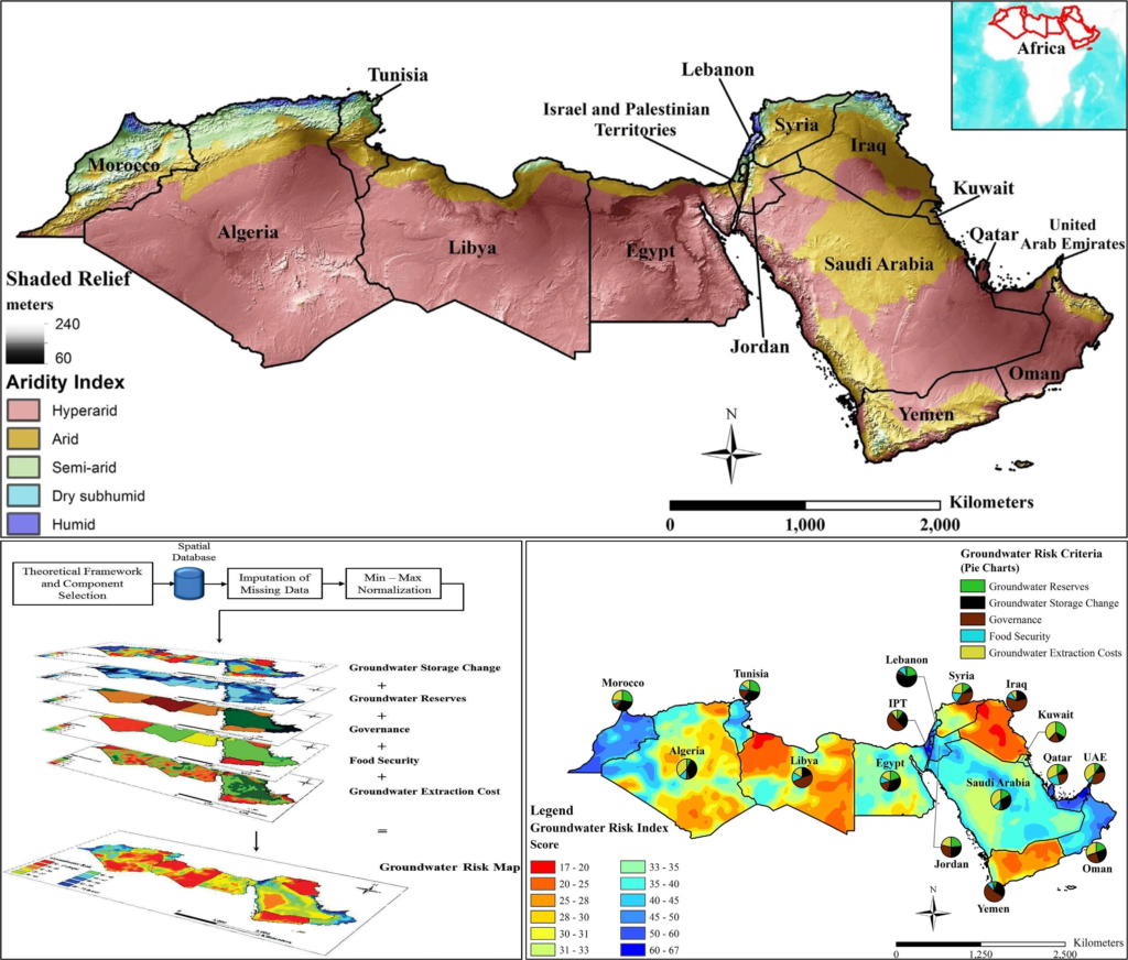
Overreliance on predominantly non-renewable groundwater resources and their subsequent depletion has given rise to adverse environmental, political, economic, and social effects. The high costs of groundwater depletion are exacerbated by the notable absence of tools designed to identify and diagnose areas at risk of groundwater degradation. In this study, a Groundwater Risk Index (GRI) was developed as a distributed composite index to assess and evaluate groundwater depletion risk by combining different environmental and socioeconomic datasets and models. GRI is designed to be used by end-users (e.g. governments, NGOs) as a multicriteria diagnostic tool to identify and determine the probability and severity of an entity experiencing the adverse effects of groundwater mining.
For more details refer to:
A Quantitative Assessment of Groundwater Resources in the Middle East and North Africa Region
Due to data paucity, comprehensive regional-scale assessments of groundwater resources in the Middle East and North Africa (MENA) region have been lacking. The presented study addresses this issue by using a distributed ArcGIS model, parametrized with gridded data sets, to estimate groundwater storage reserves in the region based on generated aquifer saturated thickness and effective porosity estimates. Furthermore, monthly gravimetric datasets (GRACE) and land surface parameters (GLDAS) were used to quantify changes in groundwater storage between 2003 and 2014.
For more details refer to:
A Global Hot Spot Analysis of Groundwater Storage Change using GRACE Satellite and GIS-Based Spatial Statistical Analysis
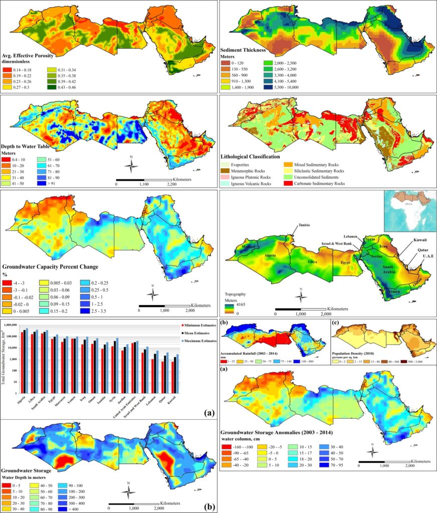
This study utilizes alternative remote sensing approaches to delineate the distribution of global groundwater storage change (GWSC) and its relationships to global precipitation rates.
NASA’s gravity recovery and climate change experiment (GRACE) mission satellite was used to derive GWSC estimates for the purposes of identifying spatial clusters of hot spot (HS) and cold spot (CS) GWSC values. A 10° x 10° grid was utilized to generate GWSC estimates by isolating GLDAS – derived surface water parameters from GRACE-derived total water storage change signal. Resultant GWSC estimates underwent a hot spot (Getis-Ord Gi*) analysis to map statistically significant spatial clusters of GWSC HS/CS with a 99% confidence interval. Moreover monthly TRMM 3B43 datasets were similarly analyzed to produce HS/CS precipitation areas that were compared to GWSC hot spot analysis results.
For more details refer to:
https://gsa.confex.com/gsa/2014AM/webprogram/Handout/Paper249527/Khalil_GSA%20poster%202014.pdf
GRACE-Based Analysis of Total Water Storage Trends and Groundwater Fluctuations in the North-Western Sahara Aquifer System (NWSAS) in North West Africa
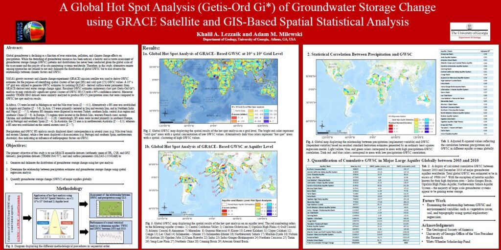
Optimal water management practices and strategies, in arid and semi-arid environments, are often hindered by a lack of quantitative and qualitative understanding of hydrological processes. Moreover, progressive overexploitation of groundwater resources to meet agricultural, industrial, and domestic requirements is drawing concern over the sustainability of such exhaustive abstraction levels, especially in environments where groundwater is a major source of water.
In this study, GLDAS variables (rainfall rate, evapotranspiration rate, average soil moisture), were used in combination with GRACE-generated gravitational anomalies maps, to quantify total water storage change (TWSC) and groundwater storage change (GWSC) from January 2003 to December 2010 (excluding June 2003), in the North-Western Sahara Aquifer System (NWSAS) in northwestern Africa. Separately processed and computed GRACE products by JPL (Jet Propulsion Laboratory, NASA), CSR (Center of Space Research, UT Austin), GFZ (German Research Centre for Geoscience, Potsdam), and GRGS (Groupe de recherches en geodesie spatiale), were used to determine which GRACE dataset(s) best reflect total water storage and ground water changes in northwest Africa. First-order estimates of annual TWSC for NWSAS (JPL: +5.3 BCM; CSR: -5.33 BCM; GFZ: -10 BCM: GRGS: -10.5), were computed using zonal averaging over a span of eight years.
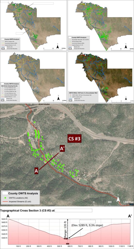
Enhancing Water Quality: Mapping Decentralized Onsite Wastewater Systems in the Southwestern United States
A federally-funded project was conducted to extensively map decentralized onsite wastewater systems (OWTS) and evaluate their proximity to surface water systems and groundwater wells in a county situated in the southwestern United States. For confidentiality purposes, any information revealing the client’s identity was redacted on the maps. The primary aim of this endeavor was to establish a clear relationship between obsolete and leaking onsite wastewater systems and the subsequent degradation of surface water quality and contamination of groundwater wells in the area. As a direct outcome of the project’s findings, enhanced access to funding was facilitated for the county to tackle the problem of outdated and leaking onsite wastewater systems.
The identifying information about the location in the maps has been masked and redacted to protect the confidentiality of the area.
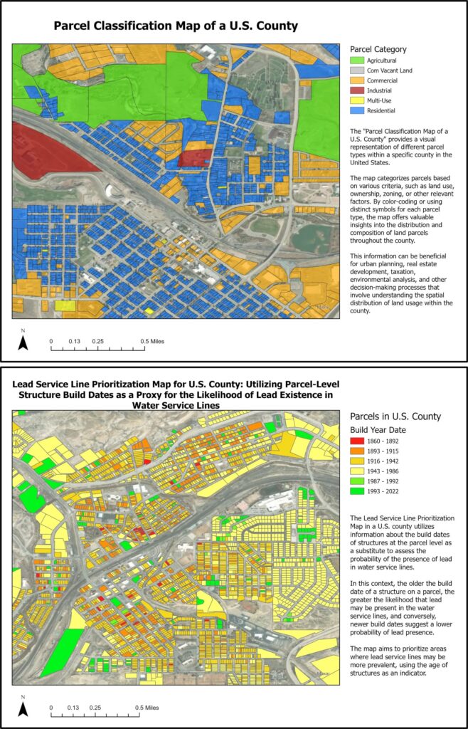
Service Line Modeling and Inventory Development Project for a U.S. State
This project focuses on developing a GIS-based model for lead service line identification in a U.S. state to support small and disadvantaged communities in meeting the Lead and Copper Rule Revisions (LCRR) lead service inventory requirements by the October 16, 2024 deadline.
The initiative involves acquiring parcel data and building construction dates, as well as incorporating existing information on lead in water service lines into the model. A scalable methodology will be devised to enhance the model and improve the lead service line inventory. Additionally, a concise guide will be developed to help utilities refine their inventories using established lead testing methodologies. For client confidentiality, all location-specific data has been anonymized and redacted.
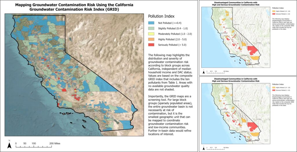
Assessing Groundwater Contamination Risks in California’s Disadvantaged Communities
To help identify communities at risk of groundwater contamination, the Office of Water Programs at Sacramento State University used openly available data for groundwater monitoring and social and economic indicators to map groundwater contamination risk across the state.
The maps featured below are designed to help managers and policymakers identify disadvantaged communities (DACs) and severely disadvantaged communities (SDACs) that physically reside over contaminated groundwater basins and may use these basins for drinking water supplies. As specified in section 79505.5 of the California Water Code, such communities are defined as:
- DACs are communities with a median household income (MHI) less than 80% of the statewide average* (MHI<$51,026).
- SDACs are communities with an MHI less than 60% of the statewide average* (MHI<$38,270).
The maps can help direct investments to clean-up contaminated groundwater wells using current and future funding. For instance, the Water Quality, Supply, and Infrastructure Act of 2014, also referred to as Proposition 1 (or Prop 1), authorized $7.545 billion in general bonds to California water projects ranging from surface and groundwater storage to watershed and drinking water protection. Prop 1 supports a multidisciplinary technical assistance program to help small, disadvantaged communities (< 10,000 people) in developing, funding, and implementing drinking water, wastewater, stormwater, and groundwater capital projects. Better identifying at-risk communities that need such funds was a motivator in creating this web-based application.
Teaching Assistant - University of Georgia
- GEOL 1121L: Earth Processes and Environments (~18 students/class), 2013–2016
- GEOL 1120: Environmental Geoscience (~90 students/class), 2015
- GEOL 1250: Physical Geology (~90 students/class), 2015
- GEOL 4220/6220: Hydrogeology (~35 students/class), 2012–2016
- Introduction to ArcGIS and Geoscience, 2012–2016
- Advancing Research & Capacity in Hydrologic Education and Science, 2013
Published Papers
- Porse, Erik, Jonathan Kaplan, Khalil Lezzaik, David Babchanik, and Patrick Maloney. “Quantifying replacement rates from indoor and outdoor urban water conservation incentives in California.” Journal of the American Water Resources Association 61.2 (2025): e70022.
- Lezzaik, Khalil, and Adam Milewski. “A quantitative assessment of groundwater resources in the Middle East and North Africa region.” Hydrogeology journal 26.1 (2018): 251-266.
- Lezzaik, Khalil, Adam Milewski, and Jeffrey Mullen. “The groundwater risk index: Development and application in the Middle East and North Africa region.” Science of the Total Environment 628 (2018): 1149-1164.
- Milewski, Adam, Khalil Lezzaik, and Rachel Rotz. “Sensitivity analysis of the groundwater risk index in the Middle East and North Africa region.” Environmental Processes 7.1 (2020): 53-71.
Technical Reports
2023
- Office of Water Programs at Sacramento State University. (2023). “Supervisory Control and Data Acquisition (SCADA) Master Planning” Report prepared for the County of Hawaii, Department of Water Supply.
- Office of Water Programs at Sacramento State University. (2023). “Sewer System Management Plan for China Camp State Park” Report prepared for the California Department of Parks and Recreation.
- Office of Water Programs at Sacramento State University. (2023). “Sewer System Management Plan for Marconi Conference Center” Report prepared for the California Department of Parks and Recreation.
- Office of Water Programs at Sacramento State University. (2023). “Sewer System Management Plan for Hearst San Simeon State Historical Monument” Report prepared for the California Department of Parks and Recreation.
- Office of Water Programs at Sacramento State University. (2023). “Sewer System Management Plan for Hearst San Simeon State Park” Report prepared for the California Department of Parks and Recreation.
- Office of Water Programs at Sacramento State University. (2023). “Sewer System Management Plan for Morro Bay State Park” Report prepared for the California Department of Parks and Recreation.
- Office of Water Programs at Sacramento State University. (2023). “Sewer System Management Plan for CDPR Van Damme State Park” Report prepared for the California Department of Parks and Recreation.
- Office of Water Programs at Sacramento State University. (2023). “Sewer System Management Plan for Pfeiffer Big Sur State Park” Report prepared for the California Department of Parks and Recreation.
- Office of Water Programs at Sacramento State University. (2023). “Sewer System Management Plan for Point Lobos State Natural Reserve” Report prepared for the California Department of Parks and Recreation.
- Office of Water Programs at Sacramento State University. (2023). “Sewer System Management Plan for Emerald Bay State Park” Report prepared for the California Department of Parks and Recreation.
- Office of Water Programs at Sacramento State University. (2023). “Sewer System Management Plan for Sugar Pine State Park” Report prepared for the California Department of Parks and Recreation.
- Office of Water Programs at Sacramento State University. (2023). “Sewer System Management Plan for D.L. Bliss State Park” Report prepared for the California Department of Parks and Recreation.
- Office of Water Programs at Sacramento State University. (2023). “Sewer System Management Plan for Clear Lake State Park.” Report prepared for the California Department of Parks and Recreation.
- Office of Water Programs at Sacramento State University. (2023). “Sewer System Management Plan for Samuel P. Taylor State Park.” Report prepared for the California Department of Parks and Recreation.
2022
- Office of Water Programs at Sacramento State University. (2022). “Sewer System Management Plan for Big Basin Redwoods State Park.” Report prepared for the California Department of Parks and Recreation.
- Office of Water Programs at Sacramento State University. (2022). “Sewer System Management Plan for Calaveras Big Trees State Park.” Report prepared for the California Department of Parks and Recreation.
- Office of Water Programs at Sacramento State University. (2022). “Sewer System Management Plan for Salt Point State Park.” Report prepared for the California Department of Parks and Recreation.
- Office of Water Programs at Sacramento State University. (2022). “Sewer System Management Plan for Lake Oroville State Recreation Area.” Report prepared for the California Department of Parks and Recreation.
- Office of Water Programs at Sacramento State University. (2022). “Sewer System Management Plan for Lake Perris State Recreation Area.” Report prepared for the California Department of Parks and Recreation.
- Office of Water Programs at Sacramento State University. (2022). “Sewer System Management Plan for Angel Island State Park.” Report prepared for the California Department of Parks and Recreation.
- California State Water Resources Control Board. (2022). “Summary of Environmental Effects: Evaluating effects of urban water use efficiency standards (AB 1668-SB 606) on urban retail water suppliers, wastewater management agencies, and urban landscapes (trees and urban parklands).
2021
- State Water Resources Control Board. (2021). “2021 Drinking Water Needs Assessment: Informing the 2021-22 Safer and Affordable Drinking Water Fund Expenditure Plan.”
2020
- Office of Water Programs at Sacramento State University. (2020). “Unmanned Aerial Aircraft System Applications in California State Parks.” Report prepared for the California Department of Parks and Recreation.
- Office of Water Programs at Sacramento State University. (2020). “San Juan Creek Watershed Characterization Report.” Report prepared for the California Department of Parks and Recreation.
- Office of Water Programs at Sacramento State University. (2020). “Sewer System Management Plan for Crystal Cove State Park.” Report prepared for the California Department of Parks and Recreation.
- Office of Water Programs at Sacramento State University. (2020). “Sewer System Management Plan for San Clemente State Beach.” Report prepared for the California Department of Parks and Recreation.
- Office of Water Programs at Sacramento State University. (2020). “Sewer System Management Plan for San Onofre State Beach.” Report prepared for the California Department of Parks and Recreation.
- Office of Water Programs at Sacramento State University. (2020). “Sewer System Management Plan for Candlestick Point State Recreational Area.” Report prepared for the California Department of Parks and Recreation.
- Office of Water Programs at Sacramento State University. (2020). “Sewer System Management Plan for Bolsa Chica State Beach.” Report prepared for the California Department of Parks and Recreation.
- Office of Water Programs at Sacramento State University. (2020). “Sewer System Management Plan for Doheny State Beach.” Report prepared for the California Department of Parks and Recreation.
- Office of Water Programs at Sacramento State University. (2020). “Sewer System Management Plan for Huntington State Beach.” Report prepared for the California Department of Parks and Recreation.
- Office of Water Programs at Sacramento State University. (2020). “Levee Scour Hole Research Support Memorandum.” Technical memorandum prepared for the Sacramento Area Flood Control Agency.
- Office of Water Programs at Sacramento State University. (2020). “Affordability Metric Analysis, City of Woodland, California.”
- State Water Resources Control Board. (2020). “Long-term Solutions Cost Methodology for Public Water Systems and Domestic Wells, Version 2.”
Selected Presentations
2023
- California Groundwater Contamination Risk Index (GRID). (2019). Online tool for mapping groundwater contamination risk to disadvantaged communities in California.
- Level Pool Routing Tool. (2019). Excel-based tool for calculating the outflow hydrograph from a level pool or reservoir given an inflow hydrograph and the storage-flow characteristics of the reservoir.
2022
- Office of Water Programs at Sacramento State University. (2022). “Sewer System Management Plan for Big Basin Redwoods State Park.” Report prepared for the California Department of Parks and Recreation.